Something new is currently being tested for WristNav
A new dedicated Climb View is coming to WristNav,
giving you a clearer way to see your route's elevation profile and
climb information while out on an activity.
The feature is currently undergoing additional testing and refinement
before it is ready for release. We want to make sure it performs
correctly across different routes and activities before making it
available.
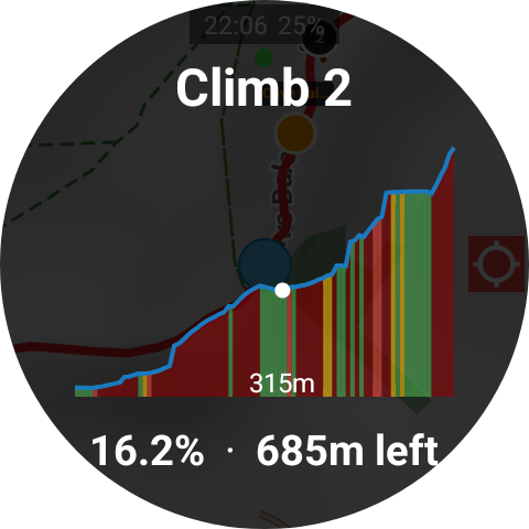
Climb View preview β feature shown is currently in development.

The standalone navigation suite for Wear OS. Offline maps, GPX routes, GPS tracking and more β directly on your wrist.
"The app stands head and shoulders above the rest, keep up the good work!"
"I really appreciate your work, you have created the perfect app I needed for my new smartwatch!"
Download maps directly to your Wear OS watch and navigate without relying on your phone or a mobile data connection.
Access downloadable topographic maps from OpenTopoMap, SwissTopo, Tracestrack, USGS and Kartverket, with a resizable download area and direct watch synchronisation.
Add a hillshading overlay to Mapsforge maps to make terrain, slopes and the shape of the landscape easier to understand.
Record your activities directly on the watch with GPS, distance, speed, elevation and other activity data.
Import GPX routes and follow them directly from your watch, with your route displayed over the map.
Export recorded routes as GPX files so you can keep, share or use your routes elsewhere.
Monitor elevation, ascent and descent during your activity, making WristNav useful for hiking and other outdoor activities.
Record heart-rate data alongside your activity. A permission issue affecting heart-rate recording in the current release has been fixed for the next update.
Track steps during recorded activities alongside your route and other activity statistics.
Configure your statistics pages to display the information that matters most to you while you're moving.
Display live WristNav information directly on compatible Wear OS watch faces using complications.
Sync activity information with Health Connect without requiring a WristNav cloud account.
Create shareable route images from your recorded activities, including the route displayed over your own photos.
Download maps using a direct URL and transfer them to your watch without having to rely on a fixed selection of sources.
Import custom map theme XML files and transfer them directly to the watch.
WristNav is designed to provide navigation directly from your Wear OS watch, without requiring your phone during your activity.
No monthly subscription and no mandatory WristNav account. Use the app without being locked into a recurring payment.
WristNav now supports downloadable topographic maps from OpenTopoMap, SwissTopo, Tracestrack, USGS and Kartverket. Choose a map source, resize the download area to suit your route, download it and sync it directly to your watch. Go to Map Settings β Map Style to switch between available map styles.
A new hillshading overlay is available for Mapsforge maps, providing additional terrain detail and making slopes and elevation changes easier to identify at a glance.
Tracestrack maps require your own free API key. You can obtain one from the Tracestrack console.
